ITU P.1546 Model
This model is used for point-to-area radio propagation predictions for terrestrial services in the frequency range 30 MHz to 3 000 MHz.
The model is intended for use on tropospheric radio circuits over land paths, sea paths and mixed land-sea paths between 1-1000 km length for effective transmitting antenna heights less than 3000 m. The method is based on interpolation / extrapolation from empirically derived field-strength curves as functions of distance, antenna height, frequency and percentage time. The calculation procedure also includes corrections to the results obtained from this interpolation/extrapolation to account for terrain clearance and terminal clutter obstructions.
Click and click the Computation tab.
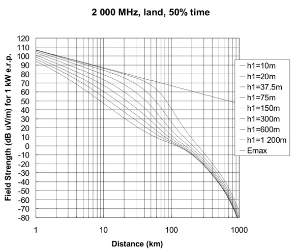
Figure 1. An example of field strength values for the ITU P.1546 propagation model.
The curves are based on measurement data mainly relating to mean climatic conditions in temperate regions containing warm seas, for example, the Mediterranean Sea. The land-path curves were prepared from data obtained mainly from temperate climates as encountered in Europe and North America. The sea-path curves were prepared from data obtained mainly from the Mediterranean Sea regions.
The model takes account of the effective height of the transmitting/base antenna, which is the height of the antenna above terrain height averaged between distances of 3 km to 15 km in the direction of the receiving / mobile antenna.
Settings
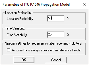
Figure 2. The Parameters of ITU P.1546 Propagation Model dialog.
- Location probability
- Location propability refers to the spatial statistics of local ground cover
variations. Thus for a land receiving / mobile antenna location the field
strength E which will be exceeded for q% of locations is given
by:where:
(1) - is the inverse complementary cumulative normal distribution as a function of probability.
- is the standard deviation of the Gaussian distribution of the local means in the study area. Values of standard deviation are dependent on frequency and environment, and empirical studies have shown a considerable spread.
- Time variability
- The propagation curves represent the field-strength values exceeded for 50%, 10% and 1% of time. Other values will be interpolated. This model is not valid for field strengths exceeded for percentage times outside the range from 1% to 50%.
- Special settings for receivers in urban scenarios (clutters)
- The ITU-1546 model distinguishes urban, non-urban, and sea areas. For low receiver heights (for example, 1.5m) the computed signal levels are partly higher in urban areas than in non-urban areas (if Rx height below the urban reference height). With this additional parameter it is possible to avoid this case and to always assume that the Rx height is above the urban reference height. Based on this the predicted urban signal levels are below the non-urban signal levels as expected.