Project Settings
The project settings for urban projects are given.
Settings
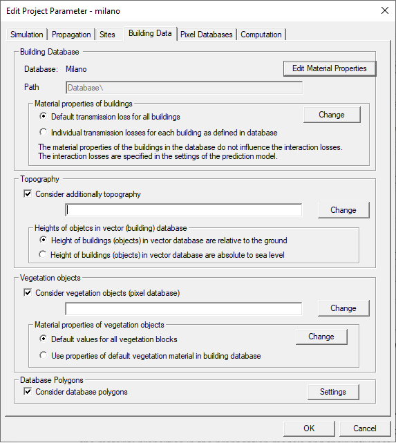
Figure 1. The Edit project parameter dialog, Building data tab.
- Building database
- You can change the database file path only.
- Material properties of buildings
- The individual material properties of the buildings (as defined in the
building database) can be used by the prediction models when the prediction
is computed or default values for all buildings can be used. This can be
selected on the Database tab of the Edit
project parameters dialog.
The COST model does not consider the material properties of the buildings. The consideration of the material properties in the propagation models and their influence on the prediction results is explained together with the propagation models, because they are used in a different way (for example the COST Walfisch-Ikegami model does not consider the material properties of the buildings at all, therefore these fields are not enabled when a COST database is loaded which allows only COST predictions).
If the individual properties are not defined in the database or if the user does not want to use the material properties defined in the database, default values can be used by enabling Default transmission loss for all buildings. In this case, all buildings are assigned the same building penetration loss independent of the definitions in the database (individually defined properties are not taken into account, for all buildings the same material properties are used). The default value can be changed by using the Change button.
-
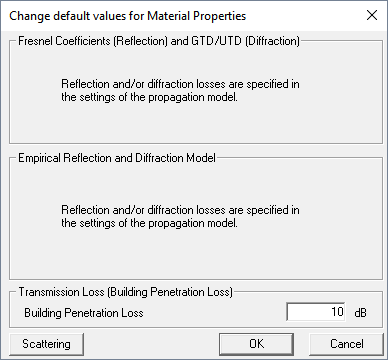
Figure 2. The Change default values for Material Properties dialog.
Ray optical propagation models, such as standard ray-tracing (SRT) and intelligent ray-tracing (IRT) use all material parameters listed in the dialog for Fresnel coefficients and GTD / UTD or the empirical transmission, reflection and diffraction model, respectively, depending on the computation mode of signal level. Semi-deterministic and empirical prediction models only use parameters for Fresnel coefficients or the values for the transmission loss, respectively, depending on the computation mode of signal level.
- Topography
- Terrain elevation data can be considered additionally. The corresponding
database file can be selected via the Change button.
After that, the heights of the buildings contained in the vector database
have to be specified to be either relative to the ground level (terrain
elevation data) or absolute to sea level.Note: This option is not available if a pre-processed database is used. In this case topography data can be considered optionally during pre-processing and is already included in the building vector database then.
- Vegetation Objects
- Vegetation data can be considered optionally. Vegetation blocks can be
included either as vector objects or based on a pixel database, which can be
specified additionally. If no vector vegetation objects are already
contained in the database, a pixel database describing vegetation can be
specified using the Change button.
For both vector and pixel based vegetation objects material properties can be specified. If pixel based vegetation objects are used or if the user does not want to use the properties defined for vegetation objects in the vector database, new values can be used by clicking Default values. In this case, all vegetation blocks are assigned the same values, independent of possible definitions in the vector database. Individually defined properties are not taken into account for vector based vegetation blocks, for all vegetation objects the same material properties are used. The default values can be changed by using the Change button. After clicking on the button, the dialog for the definition of the vegetation properties appears.
-
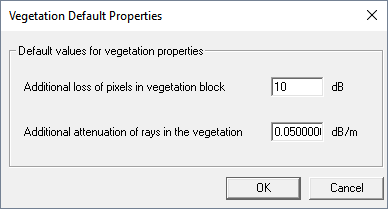
Figure 3. The Vegetation Default Properties dialog.If vector based vegetation blocks are used, the vegetation properties are defined in the vector database. These individual properties, specified for each vegetation block, can be modified with a common offset additionally.
- Clutter (morpho) properties
- For the dominant path model (DPM), morphological properties of the
area can be considered during the prediction. For this purpose, an
additional morphological database is needed. This is optional and can
therefore be disabled. The clutter database does only contain a class ID for
each pixel. The properties of the class are defined in a clutter table. This
clutter table must be additionally specified when working with clutter databases.
- Properties of clutter classes
-
For each clutter class a frequency dependent attenuation can be defined in the clutter table. You can select if this additional attenuation is considered during the prediction or if the value is neglected. If no properties for a class ID are found in the clutter table, you can decide if the software should cancel all further prediction steps or if only this pixel is not predicted.
Most propagation tools only consider the class at the receiver pixel for the influence on the wave propagation. But this means, that if 90% of the distance between transmitter and receiver are, for example, in the clutter class urban and only the receiver pixel is in the class forest, the properties of the class forest would be used. This is obviously not correct if 90% of the area between transmitter and receiver are urban. Therefore, WinProp offers optionally the determination of the dominant class between transmitter and receiver and this class is then used for the evaluation of the receiver pixel. But some classes have a greater influence on the propagation than others. Therefore, each class can be assigned a weight factor. The higher the weight factor the stronger the influence of the class on the propagation.
Example: If 1 urban and 3 water classes are between transmitter and receiver and all classes would have the same weight (for example 1), the dominant class would be water. If the weight factor of urban would be 5 and the weight factor of water would be 1, the dominant class would be urban, because the total weight of urban would be 5 (1 class * 5 weights) compared to the total weight of water which would be 3 (3 classes * 1 weight).
In order to avoid the impact of the URBAN clutter classes (clutter names like urban, dense_urban, high_buildings, residential) on areas where building vector data is already considered in the urban DPM, you need to define the corresponding clutter losses and/or heights to 0 in the clutter table.
- Database polygons
- To manage the database areas, select the Consider database polygons check box. For more information refer to Reduce Computation Time for Large Databases.