Automatic Distribution
Sites and transmitters can be automatically distributed based on topography and land usage (optional) data in rural environments. Four different distribution modes are given.
Sites and transmitters can be automatically distributed based on topography and land usage (optional) data in rural environments. ProMan offers four different distribution modes, which make it easy to distribute a large number of sites within a given area. The configuration of the site to be distributed can be specified arbitrarily by adjusting the parameters of the default site on the Sites tab of the Edit Project Parameters dialog.
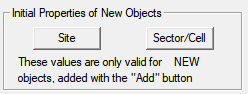
Figure 1. The Initial Properties of New Objects dialog.
The generation and distribution of the preconfigured site can be started by clicking .
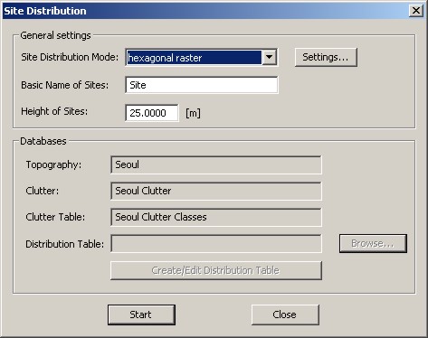
Figure 2. The Site Distribution dialog.
- Site Distribution Mode
-
The specified default site can be distributed using four different modes.
- The hexagonal raster option will place the sites according to a hexagonal grid starting at the lower-left corner of the topography database. The radius of the hexagons, as well as the distance to the lower-left and the upper-right corner of the database, can be specified by clicking on the Settings button.
- The homogeneous mode will distribute the sites randomly with a predefined, homogeneous density of sites per square kilometer. The site density to be used can be specified by clicking on the Settings button.
- If additional land usage (clutter) data is available, the “land usage” mode makes it possible to define an arbitrary density of sites per square kilometer for each clutter class separately. As an example, it is therefore easy to omit areas declared as water or forest.
- The option Fixed number of sites will randomly distribute a given, fixed number of sites. The number of sites to be generated can be specified by clicking on the Settings button.
- Basic Name of Sites
- Name of the sites to be generated. This name is appended with a successive number. A change of the name will not affect the name of the default site, for example, the name will be used only for the current distribution.
- Height of Sites
- The height of the sites to be generated. The initial value corresponds to the height specified for the default site. A change of this value will not affect the value given for the default site, for example, it will be used for the current distribution only.
- Databases
- File paths and file names of the available databases.
- Distribution Table
- Load, create or edit a site distribution table, which is used for the site distribution mode “land usage”.
Use Land Usage Data for Distribution of Sites and Transmitters
If additional land usage (clutter) data is available, the distribution mode “land usage” makes it possible to define an arbitrary density of sites per square kilometer for each clutter class separately. Therefore, a distribution table has to be defined to map the specified distribution classes to the IDs of the clutter classes where the given distribution shall be applied.
The following sample shows a distribution table with three distribution classes. For the land usage classes “open”, “sea”, “forest”, no sites shall be generated. Therefore, a distribution class “No Site” was created with a site density of 0 sites per square kilometer. Three clutter classes have been assigned to the “Low Density” distribution class, where only one site within two square kilometers shall be created. For the distribution class “High Density”, two sites per square kilometer will be distributed randomly.
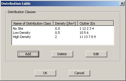
Figure 3. The Distribution table dialog.
The following dialog shows the properties of the distribution for a selected distribution class. In the lower part clutter IDs of the regions, where the specified distribution shall be applied, can be assigned.
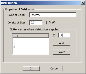
Figure 4. The Distribution dialog for a selected distribution class.
Figure 5. Example of a distribution site with three transmitters.