This task is an example of mapping using data from a .csv file.
Data in a .csv file can be based on a local coordinate system.
The format of the .csv file is x, y, z, value1, value2, and so
forth. The x, y, z data can be in a global or local system , including cylindrical.
The following mapping methods can also be selected:
Proximity
Linear Interpolation
Inverse Distance
Triangulation
In the Model Browser, right-click and select Create > Field from the menu.
In the Entity Editor, edit the field's corresponding
attributes:
Set Type to discrete.
Set System Type to real.
Set Source to .csv file.
In the File field, locate the .csv file.
In the Systems field, select the system. The system should match the x,
y, z data in the .csv file.
In the Model Browser, right-click on the field
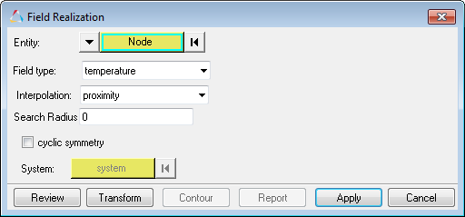
entity and select Realize from the menu.
In the Field Realization dialog, define the realization
settings:
Figure 1.
With the Entity selector, select nodes or elements that you would like
to map.
In the Field Type field, select a realization method.
Set Interpolation to proximity (finds the closest nodes) or linear
(finds nodes using the inverse distance average).