Project Parameters: Topo Tab
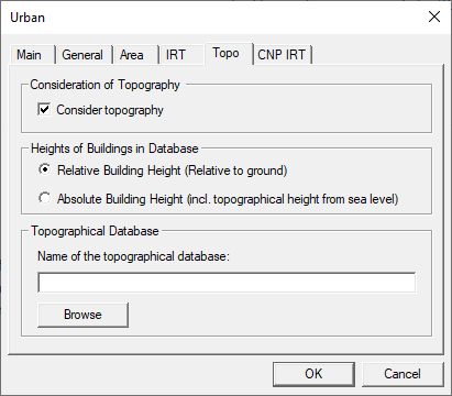
Figure 1. The Urban dialog, Topo tab.
Consideration of Topography
To consider an additional topographical database, this option must be selected. According to the terrain profile, the buildings of the database are shifted in Z-direction which leads to modified obstructions. Additionally, the height of the receiver pixels is adapted. This topography extension is applicable for all different modes empirical vertical plane models, IRT and UDP.
Heights of Buildings in Database
There are two choices concerning the definition of the building heights with respect to the corresponding terrain database. Either the building heights are given in relative coordinates, relative to street level or the building heights are defined with respect to sea level in absolute coordinates. The user must select the correct option according to the selected building database.
Topographical Database
When this option is selected also the file name of the corresponding topographical database in the WinProp format (.tdb file) must be specified. The Browse button allows the user to select the corresponding file including the terrain data. Hereby it should be ensured that the whole building database is covered by the terrain database, otherwise, there will be an error message.