Project Parameters: Area Tab
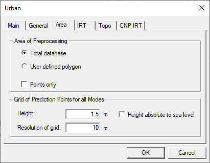
Figure 1. The Urban dialog, Area tab.
- Area of Pre-processing
-
If Total database is chosen, the whole database is pre-processed. If only a part of the database should be considered, the User defined polygon option should be selected.
In this case, the pre-processing area can be defined with a mouse tool (either rectangular or polygonal area). The definition of a polygonal area is extremely helpful for urban databases where the built-up area has not the shape of a rectangle as this approach limits the number of considered pixels.
The above options prepare for area-mode simulation in ProMan, meaning the results will be computed for an entire area. In this mode, all visibility relations will be determined for maximum efficiency during simulation. The prediction area and discretization will be fixed in the resulting file and cannot be changed later in ProMan. The option Points only is recommended in preparation for ProMan simulations in point mode (results will be computed for a set of individual points) and in trajectory mode (results will be computed along a trajectory). Slightly less pre-processing will be done, and you will keep the flexibility to specify prediction points or trajectories later, when setting up the simulation in ProMan.
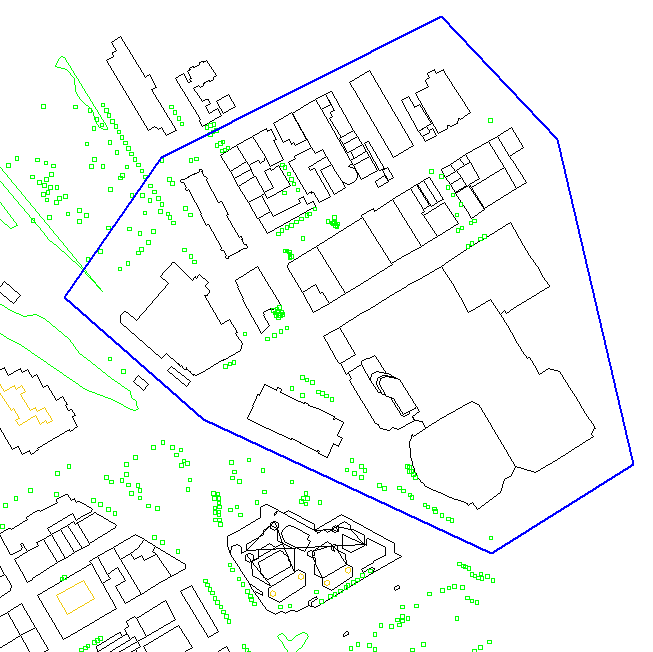
Figure 2. Definition of a polygonal pre-processing area. - Height above ground
- This value defines the prediction height relative to the ground (street or terrain level) or relative to sea level. This fixes the prediction height for simulations in area mode.
- Resolution of grid
-
This value defines the basic resolution (in meters) with which the area-mode simulation will be performed.
Appropriate values are from 2 meters to 50 meters, 10 meters is typical. The smaller the resolution of the database. This is especially the case for the IRT mode, the higher the computation time and the higher the size of the database. This is especially the case for the IRT mode, because the visibility relations for more pixels must be computed.
In general, it is advisable to rather keep a smaller resolution but choose a higher value for the reduced resolution. For example, it would be better to choose 10 meter with a reduced resolution factor of 3 instead of 15 meters with a reduced resolution factor of 2. The advantage would be that in critical parts of the prediction area (for example, narrow streets) the prediction is done in a smaller resolution, with the computation time and the database size hardly increasing.
This setting does not influence the resolution with which the building geometry is processed.