Working with Rural Projects (Vector Databases)
The wave propagation in rural and suburban scenarios is very often characterized by multi path propagation due to interactions (reflections, diffractions, scattering) at various obstacles (hills, buildings, towers). Simple empirical propagation models for these scenarios do either ignore the topography between transmitter and receiver (Hata-Okumura model, empirical two ray model) or they consider only the shadowing due to obstacles in the vertical plane (deterministic two ray model).
More sophisticated approaches include multiple diffractions in the vertical plane (knife edge diffraction models) or they compute the wave guiding around obstacles in 3D (dominant path model). All these prediction models listed above are focusing “only” on a single propagation path. But in reality there are very often more propagation paths between transmitter and receiver. And only the superposition of all these paths leads to an accurate prediction. Therefore, a (deterministic) multipath propagation model, such as the rural ray-tracing model, considering phenomena like multiple reflections and wave guiding effects in canyons is required to obtain accurate predictions of the signal level and the spatial channel impulse response.
However, this approach requires rural vector databases for the description of topography, land usage and buildings within the simulation environment.
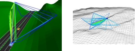
Figure 1. Rural vector databases.